


 Brick Bank
111 meters
Whitewell Close
131 meters
Mount Drive
349 meters
Cronkinson Oak
360 meters
Station View
467 meters
Brick Bank
111 meters
Whitewell Close
131 meters
Mount Drive
349 meters
Cronkinson Oak
360 meters
Station View
467 meters
 Nantwich
478 meters
The Crescent
522 meters
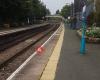
Railway Station
523 meters
Nantwich is a Station on the Crewe - Shrewsbury Branch of Transport for Wales. The st... Bus Station (Stand E)
626 meters
Nantwich
632 meters
Mount Drive
648 meters
Harvey Avenue
660 meters
Gingerbread Lane
686 meters
Willowbank
716 meters
Frog & Ferret
754 meters
Water Lode
772 meters
St Anne's Primary School
784 meters
Wyche Primary School
797 meters
Nantwich
478 meters
The Crescent
522 meters
Railway Station
523 meters
Nantwich is a Station on the Crewe - Shrewsbury Branch of Transport for Wales. The st... Bus Station (Stand E)
626 meters
Nantwich
632 meters
Mount Drive
648 meters
Harvey Avenue
660 meters
Gingerbread Lane
686 meters
Willowbank
716 meters
Frog & Ferret
754 meters
Water Lode
772 meters
St Anne's Primary School
784 meters
Wyche Primary School
797 meters
to add The Leopard map to your website;

We use cookies and other tracking technologies to improve your browsing experience on our website, to show you personalized content and targeted ads, to analyze our website traffic, and to understand where our visitors are coming from. Privacy Policy
