


 Water Lode
43 meters
Wyche Primary School
168 meters
Nantwich
207 meters
Bus Station (Stand E)
222 meters
The Crescent
478 meters
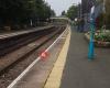
Railway Station
502 meters
Nantwich is a Station on the Crewe - Shrewsbury Branch of Transport for Wales. The st... Davenport Avenue
538 meters
Water Lode
43 meters
Wyche Primary School
168 meters
Nantwich
207 meters
Bus Station (Stand E)
222 meters
The Crescent
478 meters
Railway Station
502 meters
Nantwich is a Station on the Crewe - Shrewsbury Branch of Transport for Wales. The st... Davenport Avenue
538 meters
 Nantwich
553 meters
Malbank School & 6th Form (Bay 7)
630 meters
Having spent the best part of two years searching for a school who would safeguard, n... Station View
638 meters
Marsh Lane
681 meters
Whitewell Close
706 meters
Brick Bank
714 meters
Malbank School & 6th Form (Bay 1)
721 meters
Malbank School
733 meters
Having spent the best part of two years searching for a school who would safeguard, n... The Leopard
754 meters
Nantwich
553 meters
Malbank School & 6th Form (Bay 7)
630 meters
Having spent the best part of two years searching for a school who would safeguard, n... Station View
638 meters
Marsh Lane
681 meters
Whitewell Close
706 meters
Brick Bank
714 meters
Malbank School & 6th Form (Bay 1)
721 meters
Malbank School
733 meters
Having spent the best part of two years searching for a school who would safeguard, n... The Leopard
754 meters
 Cemetery Corner
807 meters
Cronkinson Oak
848 meters
Cemetery Corner
807 meters
Cronkinson Oak
848 meters
to add Frog & Ferret map to your website;

We use cookies and other tracking technologies to improve your browsing experience on our website, to show you personalized content and targeted ads, to analyze our website traffic, and to understand where our visitors are coming from. Privacy Policy
