


 Princess Street
383 meters
Alkincoats Road
408 meters
St Johns Church
557 meters
Always putting on great events for everyone. Handmade light up parade was just ine o... Glenroy Avenue
608 meters
Burrell Avenue
623 meters
Princess Street
383 meters
Alkincoats Road
408 meters
St Johns Church
557 meters
Always putting on great events for everyone. Handmade light up parade was just ine o... Glenroy Avenue
608 meters
Burrell Avenue
623 meters
 Colne
636 meters
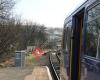
This was a good station for departure, with a long platform for the branch line servi... The Crescent
637 meters
Windy Bank Top
645 meters
Sainsburys
645 meters
Always like Sainsbury's with it's price match. Pharmacy and phlebotomy service. Great... Vivary Way
661 meters
Belgrave Road
729 meters
Rail Station
739 meters
Single line station at the end of the East Lancashire railway, handy for getting to P... Boundary Mill Entrance
754 meters
opp Carlton Court
798 meters
Bus Station (Stand 3)
810 meters
Colne
811 meters
Colne
636 meters
This was a good station for departure, with a long platform for the branch line servi... The Crescent
637 meters
Windy Bank Top
645 meters
Sainsburys
645 meters
Always like Sainsbury's with it's price match. Pharmacy and phlebotomy service. Great... Vivary Way
661 meters
Belgrave Road
729 meters
Rail Station
739 meters
Single line station at the end of the East Lancashire railway, handy for getting to P... Boundary Mill Entrance
754 meters
opp Carlton Court
798 meters
Bus Station (Stand 3)
810 meters
Colne
811 meters
to add Tennyson Road map to your website;

We use cookies and other tracking technologies to improve your browsing experience on our website, to show you personalized content and targeted ads, to analyze our website traffic, and to understand where our visitors are coming from. Privacy Policy
