


 Pembrey Farm
304 meters
Primary School
366 meters
Pembrey Farm
304 meters
Primary School
366 meters
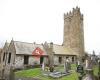
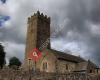 St Illtyd's Church
369 meters
St Illtyd's, foundations fifth to eighth century. Dioceses of St David's Pembrokeshir... Ship Aground
375 meters
We were so lucky to find this pub on our holiday, tempted in by the dog friendly sign... Randell Square
460 meters
St Illtyd's Church
369 meters
St Illtyd's, foundations fifth to eighth century. Dioceses of St David's Pembrokeshir... Ship Aground
375 meters
We were so lucky to find this pub on our holiday, tempted in by the dog friendly sign... Randell Square
460 meters
 Gwscwm Road
561 meters
Ashburnham Golf Club
591 meters
Stunning Sunday dinner. Even brought a pudding home as I had no room for it. Definite... Orchard Close
604 meters
Heol Panteg
619 meters
Heol Waun-Wen
662 meters
Toyota Garage
718 meters
Waun Sidan
768 meters
Tirwaun
778 meters
Tanybryn
830 meters
Gwscwm Road
561 meters
Ashburnham Golf Club
591 meters
Stunning Sunday dinner. Even brought a pudding home as I had no room for it. Definite... Orchard Close
604 meters
Heol Panteg
619 meters
Heol Waun-Wen
662 meters
Toyota Garage
718 meters
Waun Sidan
768 meters
Tirwaun
778 meters
Tanybryn
830 meters
 Cliff Terrace
835 meters
Ashburnham Bridge
949 meters
Heol Pantycelyn
983 meters
Heol Elfed
1 km
Cliff Terrace
835 meters
Ashburnham Bridge
949 meters
Heol Pantycelyn
983 meters
Heol Elfed
1 km
to add St Illtyd`s Rise map to your website;

We use cookies and other tracking technologies to improve your browsing experience on our website, to show you personalized content and targeted ads, to analyze our website traffic, and to understand where our visitors are coming from. Privacy Policy
