Queen Katherine School
166 meters
I like this school a lot but the people are too mean and nat is an ice cream, thank y... Crescent Green
498 meters
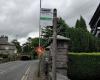
Fowl Ing Lane
624 meters
Spar Shop
865 meters
Rail Bridge
995 meters
Queen Katherine School
166 meters
I like this school a lot but the people are too mean and nat is an ice cream, thank y... Crescent Green
498 meters
Fowl Ing Lane
624 meters
Spar Shop
865 meters
Rail Bridge
995 meters
 Stagecoach Kendal Depot
1 km
Leave your car and take the stress out of travelling through the crowded lakes roads ... Kent Lea
1 km
Low Mead
1 km
This is an easy bus stop to use, however it is only a stop,there is no shelter,seatin... High Mead
1 km
Sandylands Road
1 km
Union Street
1 km
Stagecoach Kendal Depot
1 km
Leave your car and take the stress out of travelling through the crowded lakes roads ... Kent Lea
1 km
Low Mead
1 km
This is an easy bus stop to use, however it is only a stop,there is no shelter,seatin... High Mead
1 km
Sandylands Road
1 km
Union Street
1 km
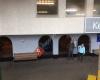 Kendal Bus Station
1 km
Kendal bus station is generally tidy and thankfully under cover, but the far end near... Hallgarth Community Centre
1 km
I enjoyed my time there met people very relaxed atmosphere you are made welcome Post Office
1 km
Abbeyfield
1 km
Kendal Bus Station
1 km
Kendal bus station is generally tidy and thankfully under cover, but the far end near... Hallgarth Community Centre
1 km
I enjoyed my time there met people very relaxed atmosphere you are made welcome Post Office
1 km
Abbeyfield
1 km
to add Morrisons map to your website;

We use cookies and other tracking technologies to improve your browsing experience on our website, to show you personalized content and targeted ads, to analyze our website traffic, and to understand where our visitors are coming from. Privacy Policy