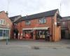
Sheepy Road
283 meters
Mill Race View
391 meters
Police Station
647 meters
Sheepy Road
283 meters
Mill Race View
391 meters
Police Station
647 meters
 Atherstone
736 meters
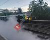
An attractive railway station with loco hauled passenger trains pass through daily an... Atherstone College
973 meters
Atherstone
736 meters
An attractive railway station with loco hauled passenger trains pass through daily an... Atherstone College
973 meters
 Bus Station
978 meters
Long Street
1 km
Long Street
1 km
New Dolphin Inn
1 km
Greencore food to go
2 km
Park up on the right hand side and book in with security. When they’re ready for you... Convent Lane
2 km
Witherley Road
2 km
Industrial Estate
2 km
Outwoods Farm
2 km
All Saints Church Grendon
3 km
Rural All Saints Church dates back to the 12th century, with the tower around 1845. O...
Bus Station
978 meters
Long Street
1 km
Long Street
1 km
New Dolphin Inn
1 km
Greencore food to go
2 km
Park up on the right hand side and book in with security. When they’re ready for you... Convent Lane
2 km
Witherley Road
2 km
Industrial Estate
2 km
Outwoods Farm
2 km
All Saints Church Grendon
3 km
Rural All Saints Church dates back to the 12th century, with the tower around 1845. O...to add Holly Lane map to your website;

We use cookies and other tracking technologies to improve your browsing experience on our website, to show you personalized content and targeted ads, to analyze our website traffic, and to understand where our visitors are coming from. Privacy Policy