


 Stewart Young Grove
416 meters
High School
421 meters
Dobbs Lane
512 meters
St Isidores
546 meters
Scopes Road
723 meters
Battles Lane
798 meters
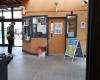
It's good bus stop however I wouldn't give 5 stars. Screen with bus arrival informati... St Olaves
813 meters
Police Headquarters
873 meters
Curtis Way
894 meters
Wolton Road
939 meters
Community Centre
999 meters
Beacon Hill Crossroads
1 km
Criss cross roadie road. Look left. Look right. Look up. Wow! Cool clouds. Look down.... Dodson Vale
1 km
Lummis Vale
1 km
Stewart Young Grove
416 meters
High School
421 meters
Dobbs Lane
512 meters
St Isidores
546 meters
Scopes Road
723 meters
Battles Lane
798 meters
It's good bus stop however I wouldn't give 5 stars. Screen with bus arrival informati... St Olaves
813 meters
Police Headquarters
873 meters
Curtis Way
894 meters
Wolton Road
939 meters
Community Centre
999 meters
Beacon Hill Crossroads
1 km
Criss cross roadie road. Look left. Look right. Look up. Wow! Cool clouds. Look down.... Dodson Vale
1 km
Lummis Vale
1 km
 Martlesham Park and Ride
1 km
easy access park and ride site, safe (opposite Suffolk polices HQ!) clean and tidy, w... Busway
1 km
Parkers Place
1 km
Martlesham Park and Ride
1 km
easy access park and ride site, safe (opposite Suffolk polices HQ!) clean and tidy, w... Busway
1 km
Parkers Place
1 km
to add St Michaels Church map to your website;

We use cookies and other tracking technologies to improve your browsing experience on our website, to show you personalized content and targeted ads, to analyze our website traffic, and to understand where our visitors are coming from. Privacy Policy
